North Queensland expecting rainfall, two cyclones on the cards now. Watch the latest forecast update here: https://youtu.be/7Pz-h9Crh2s
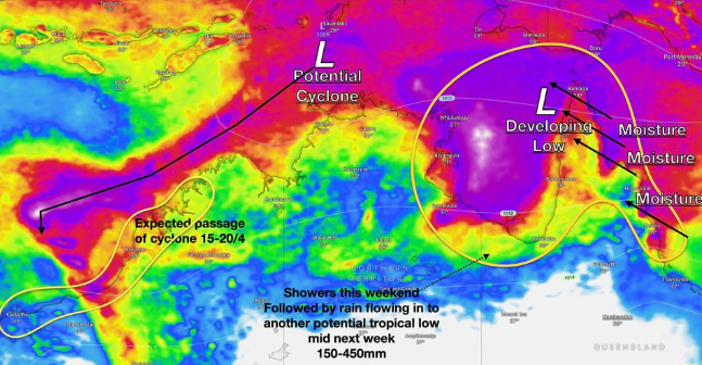
More rainfall is flowing in from the Coral sea into two developing low pressure systems offshore from the NT, with more rain falling north of Cooktown this morning. Rainfall will continue for the Cape York peninsula through today, slowly moving into the Daintree by tomorrow morning and then for areas south of Cairns by tomorrow night. Widespread moderate falls and isolated heavier falls can be expected. Rainfall will ease through early next week, however there is a chance of more rainfall building or being driven ashore as the second low develops early next week. The chances of a tropical cyclone impact across far North Queensland is extremely remote at this point in time, with rainfall being the only concern but do note that this sort of rainfall doesn’t look to be problematic and is normal for this time of the year.
Over west: the developing tropical low which is a high chance of becoming a cyclone through early next week offshore from WA is now a landfall chance for a wide range of locations between Exmouth to Broome (the chance is exceedingly small at this point in time and highly dependent on a multitude of factors including storm strength, movement and the climate). For now this is still a system to watch, not act upon.
Stay safe all, stay calm, and keep an eye on the forecast for those reading from WA. Things will develop quickly. Have a great Thursday all.